Top Landmarks in Austin

Austin, Texas has grown into a major destination in the South, and its landmarks reflect both the weight of state history and the particular outdoor-minded, culturally curious character the city has built over generations. Whether you have a single afternoon or a full long weekend, understanding how Austin's most recognized sites cluster together—and how easily they connect on foot or by bike—makes planning a lot more straightforward. This guide walks through the landmarks most commonly associated with Austin, explains what makes each one worth your time, and shows how to string them into a coherent day of exploration. For a broader overview of what the city offers, the Austin Travel Guide: Things to Do, Landmarks, Food, and Itineraries is a useful starting point.
The Texas State Capitol
No single structure is more associated with Austin than the Texas State Capitol, which anchors the northern end of Congress Avenue in the center of the city. Built from distinctive sunset-red granite quarried in the Texas Hill Country and completed in 1888, the building stands noticeably taller than the U.S. Capitol in Washington—a point Texans are rarely shy about mentioning. The grounds are open daily, the rotunda is open to the public during regular government hours (check the official Capitol Visitors Center site for current access information), and guided tours have historically been offered at no charge, though schedules and policies can change — verify current tour availability and any fees at the official Capitol Visitors Center site before your visit. The surrounding 22-acre grounds include monuments, old oak trees, and a pleasant walking loop that gives you a sense of the building's full scale. The Capitol is one of the clearest examples of how Austin's downtown is genuinely walkable—you can reach most of the other landmarks below within a 20-minute walk in almost any direction.
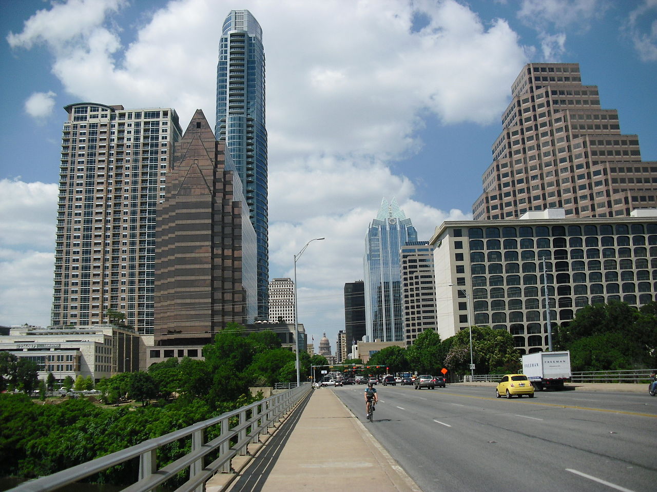
Congress Avenue and the Congress Avenue Bridge
Congress Avenue runs straight south from the Capitol steps to Lady Bird Lake, and the walk itself is part of the Austin experience. The street is lined with state agency buildings, older commercial blocks, and a string of locally owned businesses as you head toward the water.
At the southern end of Congress Avenue, the Congress Avenue Bridge is one of Austin's most popular gathering spots, specifically because of what lives beneath it: an estimated 1.5 million Mexican free-tailed bats that roost under the bridge from roughly spring through fall each year. At dusk, they emerge in spiraling columns that can take 20 to 30 minutes to clear the bridge—a spectacle that draws crowds to both the bridge itself and the grassy areas along the lake below. The timing shifts with the season, so checking with the Austin Bat Observation group or local nature organizations before you go will give you a more accurate emergence window.
Lady Bird Lake and the Ann and Roy Butler Hike-and-Bike Trail
Directly below the Congress Avenue Bridge, Lady Bird Lake stretches along the Colorado River through the heart of Austin. The Ann and Roy Butler Hike-and-Bike Trail circles the lake for roughly 10 miles and is one of the more heavily used recreational corridors in the city. Sections of the trail pass through Zilker Metropolitan Park on the south bank and connect several of the city's green spaces into a single continuous route. Kayak and paddleboard rentals are available from multiple outfitters along the shore; check current availability and pricing directly with operators, as it varies by season.
Zilker Metropolitan Park and Barton Springs Pool
On the south bank of Lady Bird Lake, Zilker Metropolitan Park covers a significant stretch of land that includes athletic fields, the Barton Creek Greenbelt trailhead, and the Austin Nature and Science Center. The most well-known feature within the park is Barton Springs Pool, a three-acre natural swimming pool fed by underground springs that maintain a consistent cool temperature year-round. The pool draws swimmers, families, and regulars on even the hottest summer afternoons. Admission fees and hours are managed by the City of Austin Parks and Recreation Department—check their official site before visiting, as seasonal hours and closures for maintenance do occur.
The Bullock Texas State History Museum
A short walk north of the Capitol, the Bullock Texas State History Museum is the state's primary history museum, covering Texas from its Indigenous cultures and Spanish colonial period through the twentieth century. The building itself is architecturally prominent, and the exhibits—spread across multiple floors—give visitors a reasonably thorough grounding in the history that shapes modern Texas. Temporary exhibitions rotate, and the museum includes an IMAX theater. Check the official museum site for current admission pricing, hours, and what's currently showing.
The University of Texas Tower and Campus
The University of Texas at Austin campus sits just east of the Capitol district and is worth exploring on foot. The UT Tower—formally the Main Building—rises 307 feet above the campus and has served as Austin's visual landmark for nearly a century. Observation deck tours are periodically available (check UT's official visitor information for scheduling). The campus also holds the LBJ Presidential Library, one of the presidential libraries administered by the National Archives, which documents the life and presidency of Lyndon B. Johnson. The library's permanent collection includes original documents, photographs, and artifacts from the Johnson years, with rotating temporary exhibitions that draw on the broader archives. Admission policies and hours are listed on the official LBJ Library site.
The Blanton Museum of Art, also on the UT campus, is a wide-ranging university art museum with particular strength in Latin American art and European prints and drawings. Admission details, including any free-admission programs, are listed on the Blanton's official site.
Mount Bonnell
About four miles northwest of downtown Austin, Mount Bonnell is the highest point within the city limits—around 775 feet above sea level—and offers a panoramic view of the Colorado River, the Hill Country, and the Austin skyline from a relatively short climb up a stone staircase. It sits within Covert Park and is open during daylight hours. The overlook is popular with locals at sunrise and sunset and is accessible by car, though parking along the approach road is limited. If you're driving in from downtown, plan for a quick detour rather than walking distance.
Sixth Street and the Warehouse District
The stretch of East Sixth Street between Congress Avenue and Interstate 35—commonly called "Dirty Sixth" by locals—is Austin's most well-known entertainment corridor, with a dense concentration of bars and live music venues in older commercial buildings. The area is liveliest Thursday through Saturday nights. The adjacent Warehouse District, along West Second and Third Streets, tends to draw a somewhat different crowd with a mix of clubs, cocktail bars, and event spaces. Both areas are walkable from the Capitol and from most downtown hotels. If you're planning around live music specifically, the Best Things To Do in Austin page has more detail on the broader music and arts scene.
How the Landmarks Connect
Austin's core landmarks fall into three geographic clusters that make self-guided touring genuinely practical.
The Capitol corridor (Texas State Capitol, Bullock Museum) spans about six blocks and takes two to three hours if you go inside both the Capitol and the Bullock. From the Capitol, walking south down Congress Avenue to the bridge takes roughly 15 minutes.
The lakefront and Zilker (Congress Avenue Bridge, Lady Bird Lake trail, Barton Springs Pool) anchor the south end of downtown. The trail between the bridge and Barton Springs Pool is about two miles of easy flat walking.
The UT campus (UT Tower, LBJ Library, Blanton Museum) sits about 10 to 15 minutes on foot northeast of the Capitol. Many visitors combine a morning at the Capitol with an afternoon on campus, then return downtown for the Sixth Street area in the evening.
Getting between clusters is straightforward by bus or rideshare, and Austin's downtown street grid is easy to navigate. The city has expanded its transit options in recent years; check Capital Metro's official site for current routes and fares before you travel.
Planning Your Visit
If you only have one day in Austin, the Austin 1-Day Itinerary offers a practical sequence that works around the most commonly visited sites. For a longer stay, the Austin 3-Day Itinerary gives you room to include Mount Bonnell, a full afternoon at Barton Springs Pool, and more time on the UT campus without feeling rushed.
Austin's climate has a real effect on which landmarks are comfortable to explore and when—the Best Time to Visit Austin page breaks down seasonal trade-offs in practical terms. And if you're still sorting out logistics, the Austin FAQ covers common questions about transportation, neighborhoods, and timing.
Wherever your Austin itinerary begins, the landmarks above give you a solid foundation—and enough variety in character that no two days of exploration feel quite the same.